20 Best Tips

Traveling Russia: Week 1

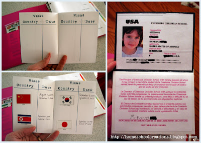
This last week we started our study of Russia with the girls. I haven’t had a chance to sit down and pull all my thoughts together until now, so I might miss some stuff that we did because there have been moments when we have veered off course from my plans and I keep forgetting to pencil in what we actually did {sigh}.

That said, I can give you a basic framework of what our week looked like, include some links that we/I used, the books we used, and one of the worksheets that I pulled together for us. I’m also working on putting a post together that talks about some of the specific things that I try to do for each country that we study (and might go into a little more detail in this post too about how we did some of the things to give you an idea).

Monday

  • Locate and map Russia. We have a wall map and globe that we use for this. The girls find the country on the map and we talk about a few different things: what continent the country is on, which hemispheres, what other countries it is near, etc…
  • Introduce our new geography song. I can’t say enough about how much we have enjoyed the cd Geography Songs and how much the girls (and Zachary by default) have learned from this cd. This week we learned the song "Former USSR". As we sing the song, we find the other countries that are mentioned in the song and work on remembering where the countries are and pointing them as we sing along.
  • Use our atlas to learn more about Russia. We use The Children’s World Atlas from Rand McNally. We read the little blurbs in the book on industry and other key facts about the country: population, major cities, etc…
  • Find the capital of the country

Tuesday

  • Read Children Just Like Me and complete the worksheet. I made a worksheet to go along with the book, so after we read about the child from the country we are studying, we fill in the information we learned (what city, religion, language, favorite foods, etc…)
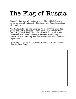
  • Learn about Russia’s flag. This week I made up a little worksheet about the flag of Russia (you can print it off below).
  • Review our geography song
  • Talk about some interesting facts about Russia: it is on two different continents (found dividing point), 11 different time zones, takes up almost all of Eastern hemisphere

Wednesday

  • Review our geography song with map.
  • Play a Russian game
  • Travel and learn a little about Russia via a website – a virtual tour

Thursday

  • Review our geography song
  • Learn about the language(s) spoken in Russia and different religions. We also used this time to talk about the time that Russia was under Communist rule and people weren’t allowed to believe in God.

Here are some of the books that we used this week in our studies:

Some great websites and links related to Russia:

This is the worksheet I put together on the Russian flag:

Next week we will be continuing our time in Russia and learning about the currency of Russia, making a meal, studying the different geography features of Russia and the climate and more so be sure to check back or look for the second link/post.

Jolanthe Signature affiliate button

Our Geography Travel Log

To keep track of our travels around the world using a notebook approach of sorts. I’ve found a way to include the lapbooks that we’ve made to go along with our studies and we are also having fun stamping our passports each time we leave a country that we’ve been studying.

Just to give you a peek into our binders, here’s how I set them up. I belong to a yahoo group that had the files to print off for the binder cover. We are using Flag It World Flag stickers as our "passport stamps" as well as the blank passports that I found to use from Rainbow Resource (you can buy both together and save a little bit).

The binders were picked up at Walmart and I bought a set of 8 tabbed dividers so we had place to put info from each continent and its’ countries behind each divider. The binder collects and holds all the things that we create: our flags, country information sheets, Children Just Like Me sheets, currency sheets, etc… anything that might be fun for the kids to flip through later and remember what we studied.

When we create lapbooks that are related to the countries that we study (China: Pandas, India: Tigers, Japan: Volcanoes), I found a way to put them in the back of our binders so that they are all in one place. I cannot remember for the life of me where I saw the idea to use the duct tape on the side of the lapbook, so I apologize in advance. It’s been extremely helpful though, so I put together a separate post on how to store lapbooks.

Once our study of a country is done, the girls find the flag sticker belong to that country and we put it in our passport along with the dates that we studied that country. The passports were blank and I used some of my alphabet stamps to stamp each page and then a marker to divide and section out the pages for the dates and stickers. The front cover design of the passport was also a file that I found via a yahoo group (and there are not big black blots on the actual passport like you see in the picture – I just blotted them out since there was some personal information on the picture).

Hope this helps some of you all out in picturing how we are pulling it all together in our studies. If you have any questions, feel free to post and ask.

Jolanthe Signature affiliate button

Antarctica: Learning about Shackleton

I’d love to say that I single-handedly came up with the lesson plans for our final week in Antarctica, but since I found some that were amazing, I have to share them!

We found the movie Shackleton’s Antarctic Adventure through Netflix and we watched it several times. I even cried watching it! The story is absolutely amazing, and if you haven’t heard about it, this is one that you should really check out! You can see a trailer of the film here.

The lesson plans that I found go along with the movie and provide a HUGE resource for teachers and students to follow along and learn more about Shackleton. You can access the full set of plans here and there is also a family movie guide too.

Using the guide, here’s how our week looked:

Monday – We watched the movie together after working on some of our general schoolwork. We also spent a little time on the NOVA online site looking at virtual 360 pictures of various places in Antarctica.

Tuesday – We tracked Shackleton’s expedition using latitude and longitude and the timeline that was provided. We followed along mapping where he first started out, where his ship got stuck and crushed, where the crew was stranded, and eventually where the crew was rescued.

I have to say that McKenna absolutely amazed me during this activity. She was mapping points so quickly and accurately! Have to say that I was rather impressed. :)

Wednesday – We did another journaling activity called “In Your Own Words”. First, we read through different journal entries from Shackleton and his crew. When we were done reading through those entries, we created some of our own entries journaling our day.

Thursday – We did an activity called “What’s on Your Plate?” comparing the things that we ate during our day and what a typical day for Shackleton’s crew might have been. We figured up caloric values and also talked about the differences between carbohydrates, proteins, and/or fat.

Here are some other great resources on Shackleton also:

Hope these resouces help you all out! Can’t tell you how much we’ve enjoyed spending time in Antarctica!

Antarctica ::Week 2::

We continued on our journey to the bottom of the Earth this past week – all of us absorbing MUCH more information and having a great time exploring a continent that we didn’t think would be all that exciting! Just today (Sunday) I found some more great links and asked the girls what they would like to do next week and had a very loud: MORE SHACKLETON!! So we’ll be spending a few more days in Antarctica it seems and then moving on to a unit study on penguins for the oldest three.

I will be sharing a ton of the great links that we’ve been using this last week at the end of the post, so be sure to check them out. It is by no means a complete collection, but there are guaranteed to be some great helps for you in the list.

Here’s a look into how our week worked out:

Monday

  • Reviewed some of our studies from last week (Antarctica is the 5th largest continent, 99% ice, coldest and windiest continent)
  • Continued on our virtual field trip…which led us off on several fun bunny trails
  • Started learning about Shackleton, an explorer to Antarctica
  • Watched some fun clips on the Southern lights and talked about what causes them. This was our favorite clip.

  • played “name that hemisphere” and talked about what hemispheres that Antarctica is in: south, east and west

Tuesday

  • Learned more about the animals in Antarctica and watched a movie from National Geographic (which ended up being more of a “snooze-fest” for a certain younger student)

Wednesday

  • Learned about different types of plant life in Antarctica: lichen, moss and alga
  • Talked about why so few plants grow in Antarctica
  • Learned why plants around Antarctica grow better in the ocean than on Antarctica

Thursday

  • Talked about the different men that have attempted to explore and have succeeded in first exploring Antarctica: Amundsen, Scott and Shackleton.
  • Traced the routes of Amundsen and Scott and compared their different journeys to the South Pole (who was successful, who wasn’t, how they compared to each other)
  • Wrote fictional journal entries from the point of view of Amundsen (the first to reach the South Pole). These were hysterical!!

Here is Laurianna’s fictional journal entry:

“I won the race! I can’t wait to return home. I hope Scott found the tent and the letter. We had to kill a lot of the dogs for our trip back home.”

And McKenna’s entry (apparently left at the tent for Scott to find when he arrived behind Amundsen – spelling is her’s):

“I won the race! I’m very happy that I did. You were vary nise. I saw a pengwin today.”

Here are some of the wonderful links that we used this week in our studies:

Our trip will continue next week, so be sure to check back to see more about our studies on Shackleton. We are having so much fun with this study. If you would like more info on Antarctica and links, be sure to check out my first post of our studies, To the Bottom of the Earth: Antarctica for Kids ::Week 1::.

To the Bottom of the Earth: Antarctica for Kids ::Week 1::

When I initially set out our yearly plan, I “budgeted” time for the various countries and continents that we were going to be studying, Antarctica included. I figured that we could get everything done for the North and the South Pole in 2 weeks.

Because, really. It’s just a snowy landmass, right?

We started studying Antarctica this last week and it’s looking like this could be a much longer study that I originally thought. The girls (and I) are learning so much…and having a lot of fun with it in the process, so we are only going to study Antarctica for now and then do a unit study/lapbook on penguins.

We found a GREAT video clip showing a penguin being chased by a pod of orcas. The video clip is below. It’s about 5 minutes long but really rather funny.

I found a copy of Antarctica by Evan Moor at a book sale and it has been a huge help in our studies. The more I dig and search on the internet, I also find some other great sites, which I’ll share a little later. Here’s a look at our week (just the geography/Antarctica related things):

Monday

  • Locate Antarctica on our map and globe
  • Use Children’s World Atlas to learn more about the geography features and other information about Antarctica
  • Talk about the meaning of the name Antarctica (opposite of the Arctic)
  • Looked at the differences between a flat map and a globe and how that changes the look of a continent (especially Antarctica)
  • Talked about the differences between the hemispheres (North/South and East/West) – which hemispheres is Antarctica in?
  • Tuesday

  • Talked about the climate/weather on Antarctica
  • Looked a little more at the geography of Antarctica and what is under all that ice
  • Talked about the oceans that surround Antarctica
  • Wednesday

  • Touched a little bit on the first explorers to Antarctica: Scott and Amundsen (we will be doing more study on them next week)
  • Found some sites online that show some of the research centers in Antarctica
  • Started our “internet field trip” to explore and learn more
  • Thursday

  • Talked about krill and why there is an abundance of it at the South Pole
  • Drew a picture of krill and journaled a little about krill
  • Looked at the Antarctic Peninsula and the climate changes throughout the year
  • Here are some of the websites that we used this week:

  • Cool Antarctica – this site has the most amazing pictures, facts, history. A very comprehensive site
  • Tramline – an internet field trip that has teaching resources and one we’ve had fun using. There are some dead links as you click through the links, so you just need to go on to the next link.
  • Antarctica! – A collection of material that was originally started as part of a university field-trip course, but has been updated recently. Also has some video and picture links.
  • Beyond Penguins and Polar Bears – an online K-5 magazine for teachers. They have a unit designed specifically for Mapping the Polar Regions, comparing the North and South Poles.
  • Ducksters – Map of Antarctica and other Antarctica facts
  • Popular Mechanics – a look at the Amundsen-Scott Research Center
  • And a few of the books that we used in our studies:

    Next week we will be studying more about the animals and plants in the Antarctic and also look more at the expeditions to the South Pole in the early 1900’s.

    Israel for Kids: Week 2

    We’ve been continuing on in our study of Israel this last week and a half. The girls spent a little more time visiting some websites this week for some virtual tours – which they were thrilled with. In addition we’ve also spent time doing the following:

    • Continued practicing our new geography song about the Middle East (from Geography Songs)
    • Used the book Welcome to Israel: Talked about the size of Israel (similar to New Jersey), the history of Israel and the birth of Israel as a nation, the first Jews (Abraham and Sarah), the Star of David, and the Dead Sea (lowest point on Earth)
    • Mapped a more detailed map of Israel (Enchanted Learning) and also a map of Israel and its neighbors (love this one!)
    • Learned about Israel’s currency (and made up a notebooking sheet for it)
    • Made a dinner of Baked Felafel Sandwiches with a side of hummus for dipping
    • Took a little quiz to see what we had learned about Israel {click on thumbnail below to download pdf}


    Sites We Visited 

    • Israel Embassy for Kids – a virtual trip to Israel for kids that helps kids learn about Israel’s currency, geography and much more – the girls loved this!
    • 100 Ideas for Teaching Israel – some great ideas on this page. We used several of these this week in our study of Israel
    • Time for Kids – mapping activity for kids focusing on Israel and its neighbors
    • About.com: Judaism – free Israel coloring pages for kids
    • Israel currency – notebooking page I made showing the paper currency of Israel
    • Yahoo Kids – quick facts about Israel
    • Go Israel.com – Israel’s ministry of tourism, includes maps and pictures. Also has some great videos that the kids loved!

    Books We Used 


    Jolanthe Signature affiliate button