20 Best Tips

Continents Fact Files Printable – Geography Printables

continent-fact-files-and-flash-cards-from-homeschool-creations_edited-1 

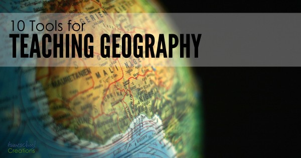
This year Kaleb and I have been wandering around the world via books, Little Passports, and various other things we come across in our travels. We have a slew of resources and to go along with a few of our books, I put together some printables where we could track important information related to the countries. 

continent-fact-files-printables-from-homeschool-creations_edited-1


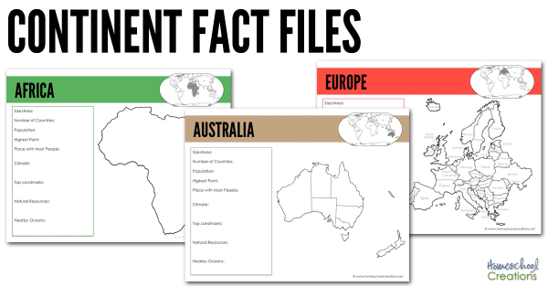
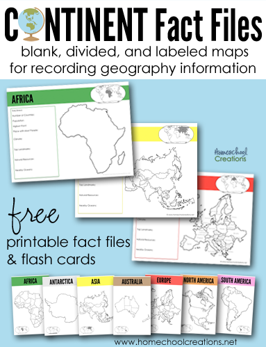
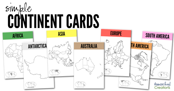
There are several pages for each continent: a blank continent image, one showing countries/territories within the continent, and another labeling each of the countries/territories within the continent (Antarctica only has one page). 

All continent fact pages were designed using the traditional Montessori colors: Africa (green), Antarctica (white), Asia (yellow), Australia (brown), Europe (red), North America (orange),  and South America (pink). 

Each page has room to record the following information and also shows where that continent is in comparison to other continents: 

  • Size/Area
  • Number of Countries
  • Population
  • Highest Point
  • Place with Most People
  • Climate
  • Top Landmarks
  • Natural Resources
  • Nearby Oceans

We’ve been using the below books to help us fill in the information blanks on each continent fact file: 


simple-continent-cards-from-homeschool-creations

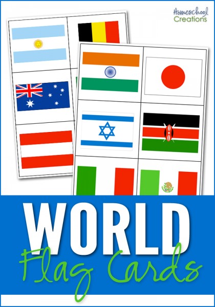
The set also has seven half-sheet printables we recommend printing off onto cardstock and laminating. Use them as larger flash cards to show the various country/territory divisions on the continents. We have a copy in each of our continent boxes and will put them on the wall above our map when we are studying the continent. 


We also highly recommend taking part in a Little Passports subscription! Not sure which adventure to choose for your explorer? Check out these Little Passports blog posts and learn more about their four subscription options:

Download the Continent Fact Files & Continent Cards

Your family is more than welcome to download the 23 page Continent Fact Files as well – and we hope they are a help to you!

 Download button


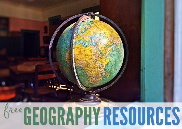
More Geography Resources


world flag cards for matching free homeschool geography resources 10 tools for teaching geography - hands on ways to incorporate geography learning

Click on one of the globe to search for geography resources by continent. Each page has downloads for flag coloring and information pages, mapping pages, and links to blog post full of lesson plans and additional information.


Africa   Asia   Australia
Europe    North America    South America


10 Tools for Teaching Geography & Exploring the World

10 tools for teaching geography - hands on ways to incorporate geography learning

We are barely finished with this school year, and over the last few weeks (ok, months) I’ve been piecing together what we will be doing during the upcoming school year. One of my initial plans for this past year was to work on world geography with the boys. Unfortunately, I went a little overboard in my mind and it was put to the side – mainly because I wanted to reinvent the wheel and put together a billion ideas (which were all good) into creating our own curriculum. 


Rather than running myself ragged – and truthfully in an effort to keep it more simple – I’ve decided to use something that is already pre-planned – Elementary Geography and Cultures from Masterbooks. It’s a curriculum I’ve been eyeing for quite some time (thanks to my friend Carisa) and includes the books Passport to the World and the Children’s Atlas of God’s World .  Yes, I will likely end up reworking some of my past geography printables and also create a few additional go-alongs for what we are doing, BUT I am so very excited about this one year world geography plan. 

Now, while having a curriculum framework to follow is great, the most effective way to teach our kids geography is through the hands-on tools that go along with ANY curriculum. Here are 10 tools for teaching geography – all things our family has used (and will use again) to keep learning fun.

10 Tools for Teaching Geography

10 tools for teaching geography and exploring the world

1 // Read Lots of Literature (and then some more)

One of the things we enjoyed the most our first geography go-round were the many books that are available based on the countries we studied. From missionaries that served in the country to picture books about artists or scientists, there is an amazing abundance of books to read and learn through. If you’d like to see the books we read through before, check out this page and click on the continent link to see favorites by country. 

2 // Play and Learn Music

Music can be one of the best tools to use for children to memorize things. Our girls used Geography Songs and we’ll use that again for learning countries, bodies of water, and continents.

Also spend time listening to composers who were born in the different countries or music that is native to the geographical areas. Take a trip to your library and check out a few CDs or have fun browsing YouTube to see traditional dances. 

3 // Create Art

Amazon Animal Chalk Pastel-17

Learn about artists native to the country you are studying or special art styles that are based in a geographical region.  When we were studying the Amazon, we used chalk pastels to draw frogs, toucans, and other animals from the rainforest. They were some of our favorite drawings we’ve done! 

4 // Create Continent Boxes

Put aside and group all of the hands-on materials you collect into boxes (or bags) based on countries or continents. Over the years we’ve collected many fun things (some from our subscription to Little Passports) and also some new materials (I am absolutely in love with TOOBS and their animals and landmark figures). I’ve purchased seven photo storage boxes to keep all our materials in one spot. (Thanks to Counting Coconuts for the idea.)

5 // Learn about the Animals

Include a little science learning into each geographical area you study by looking at animals that are native to to that country. Our girls loved learning about kangaroos and koalas when we studies Australia, peacocks when we learned about India – and there are so many more. Learn about their habits, diet, and classification. We often created lapbooks and those stayed on our shelves to review for years to come.

6 // Eat and Cook a Special Meal Together


Cooking is not only a life skill for kids to learn, but it can be a memorable way to learn about a country. Depending on the country you are studying, pick a recipe or create a meal that would be native to that country (granted Antarctica might be a little hard…), but snow cones might be a favorite! Every now and then we would treat the kids to a special meal out if we had a great restaurant in town, because sometimes the cultural experience is equally (or even more) fun. If Pinterest is too overwhelming, the book Eat Your Way Around the World is full of recipes to try.


7 // Put a Puzzle Together

While you are reading out loud or keeping fidgeting kids busy, pull out a puzzle and work on it together. We have all of the GeoPuzzles and absolutely LOVE them. Rather than being regular shaped puzzle pieces, each piece is shaped like the countries within that continent. 

8 // Make Lego Creations

Using Legos in the Classroom

Legos may never leave our home. Our kids have a plethora of them, and we will definitely be incorporating them into our geography time filling out blank outline maps, building famous landmarks…or getting a good laugh in when the kids depict the most hilarious historical scenes with LEGOs. (Sometimes you just have to laugh even though beheading are no laughing matter.)

9 // Draw Through the Countries

Have a child that loves to draw? Pull out the Draw Write Now series and let your kids illustrate their way around the world. Use the Draw and Journal pages to draw a picture of an animal or landmark in that country and write down a few facts to go along. Our kids love to draw while I’m teaching – and it can help them remember facts better as well. Geography Through Art is another great book that includes art projects using different mediums – from all around the world.  

10 // Use Geography Printables

free geography resources

If you know me well, you’ll know that I love creating printables that help our kids in the learning process. Over the years we have used a variety of printables, both ones I’ve pulled together and ones from other blogging friends. Here are a few free geography resources


Those are a few of the ways we incorporate fun into our geography studies – how has your family expanded geography learning together? 


Learning About Our Country ~ the United States

The United States was the last country that we studied in our two year world geography study.  Since we were going to be doing Early American History in the upcoming year, we just did a general study to get the basics in ~ because really, there is SO much you could do!

The United States is the third largest country in the world and located on the continent of North America. There are six different regions in the US: New England, the mid-Atlantic, the South, the Midwest, Southwest, and the West.

You can view the other countries that we’ve studied from North America on my North America geography page. See the other countries that we’ve studied

Week 1 Layout

Monday

  • Introduce new song about the United States from Geography Songs
  • Use atlas and globe to locate the United States
  • Read one of our books from our bookshelf about South Africa

Tuesday

  • Review geography song
  • Learn {and review} some terms: mountain range, desert, plains
  • Independent reading from bookshelf
  • Filled out the map of the United States using our notebooking page

Mapping US

 Click on thumbnail to download pdf file

Wednesday

Thursday

Week 2 Layout

Monday

image

Click on thumbnail to download pdf file

Tuesday

Wednesday

 
Thursday

  • Review geography song
  • Summarized one of our reading books and copy summary/dication
  • Added our notebooking pages to our binder and stamped our passports!

Books To Use


Resources and Websites

O Canada! ~ Lesson Plans and Resources

Canada spans more than half of the Northern Hemisphere and is the second largest country in the world. It also has the world’s longest coastline ~ there are oceans on three sides. Canada’s lakes and rivers make up about 20% of the world’s fresh water.

The population of Canada is less than half a percent of the world’s population. The majority of Canada’s people live in the southern part of Canada and the largest cities are Montreal, Toronto and Vancouver. Canada’s two official languages are French and English.

You can view the other countries that we’ve studied from North America on my North America geography page.

Week 1 Layout

Monday

  • Introduce new song about Canada from Geography Songs
  • Use atlas and globe to locate Canada
  • Read one of our books from our bookshelf about Canada

Tuesday

  • Review geography song
  • Learn {and review} some terms: province, hemisphere, territory, bay {Hudson bay}
  • Independent reading from bookshelf
  • Filled out the map of Canada using our notebooking page

 Mapping Canada

 Click on thumbnail to download pdf file

Wednesday

  • Review geography song
  • Took a virtual tour through Canada
  • Talked about three different explorers: Leif Erickson, Jacques Cartier, and John Cabot
  • Independent reading 

Thursday

Week 2 Layout

Monday

 Flag of Canada

Click on thumbnail to download pdf file

Tuesday

Wednesday

Thursday

  • Review geography song
  • Summarized one of our reading books and copy summary/dication
  • Added our notebooking pages to our binder and stamped our passports!

Books to Use

Resources and Websites

Off We Go to Mexico ~ Unit Study & Lesson Plans

Our first stop in our study of North America was Mexico. Mexico is three times the size of Texas and is south of the United States. The Rio Grande, the longest river in Mexico, forms the border between the US and Mexico.

Mexico has a variety of plant and animal life and also a variety of environments: desert, rainforest, wetlands, and mountains. Most of the country’s population are mestizos, people of mixed Spanish and Indian origins. During our studies we learned about the history of Mexico, tried to speak a little Spanish, did a little online sightseeing, and finished up with a yummy recipe {and one we’ll have to make again!!}.

You can view the other countries that we’ve studied from North America on my North America geography page.

Week 1 Layout

Monday

  • Introduce new song about Mexico from Geography Songs
  • Use atlas and globe to locate Mexico; read in the atlas about Mexico
  • Read one of our books from our bookshelf about Mexico

Tuesday

  • Review geography song
  • Learn {and review} some terms: gulf, river, rainforest, wetland, peninsula, coast, gulf, canyon, desert
  • Independent reading from bookshelf
  • Filled out the map of Mexico using our notebooking page

Mapping Mexico

 Click on thumbnail to download pdf file

Wednesday

Thursday

Week 2 Layout

Monday

Flag of Mexico

Click on thumbnail to download pdf file

Tuesday

Wednesday

Thursday

  • Review geography song
  • Cooking ~ Churritos
  • Summarized one of our reading books and copy summary/dication
  • Added our notebooking pages to our binder and stamped our passports!

Books To Use

Resources and Websites

Country Flag Card Printables

world flag cards for matching

I’ve been working on this printable for far.too.long, and FINALLY sat down this weekend, got productive and have it ready to share with you all! :) I put these together to help our kids identify the flags of the various countries we’ve been studying during our Galloping the Globe studies {with a few extra countries thrown in for good measure}.

There are 35 countries represented on the cards with two cards for each flag so it can be played as a ‘memory’ game. The set also contains 6 cards that represent 6 of the 7 continents {Antarctica is excluded} so the cards can also be sorted by the continent the country flag belongs to. Country name cards are also included for your child to match the names of the countries with the appropriate flag.

Since I don’t know every flag and what country it belongs to *ahem*, I included a key at the end of the document to help you all double check your answers. :)


I hope that a few of these resources help you all out ~ let me know if you all have any questions or have problems with the download.